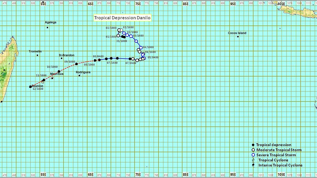
« Il est très probable que Danilo traverse le nord de l'île Maurice sous la forme d'une tempête tropicale modérée dans la nuit du dimanche 10 janvier 2021 ». C’est ce qui ressort d’un communiqué spécial émis par la station météorologique de Vacoas à la mi-journée ce vendredi.
À 10 heures, la dépression tropicale Danilo était située à environ 1 010 km à l'est-nord-est de l'île Maurice à 16,9 degrés de latitude sud et 66,7 degrés de longitude est. Danilo continue de se déplacer dans une direction générale de l’ouest à une vitesse accélérée d'environ 25 km/h.
Selon la station de Vacoas, les modèles numériques de prévision météorologique s'accordent à dire que Danilo se déplacera dans une direction générale vers l'ouest jusqu'au samedi 9 janvier. Par la suite, elle se redressera vers le sud-ouest, ce qui amènera son centre droit sur le nord de l'île Maurice ou très près de l'île Maurice. Il est probable que le système se renforce légèrement à l'approche de l'île Maurice à partir de samedi.
Le vent soufflera du sud-est avec des rafales de l'ordre de 110 km/h dans la nuit de dimanche à lundi. La mer sera forte. Le mauvais temps persistera lundi 11 janvier 2021
Rodrigues
À 10 heures, la dépression tropicale Danilo était située à environ 460 km à l'est-nord-est de Rodrigues. En se déplaçant vers l'ouest, le système passera à environ 220 km au nord-nord-ouest de
Port-Mathurin samedi matin.
Ci-dessous le communiqué de station météorologique de Vacoas :
Mauritius Meteorological Services
Tropical Weather Outlook issued at 1000 hours on Friday 08 January 2021
General
Satellite imagery shows that clouds associated with Danilo are still amorphous and rather disorganised.
However, overnight there has been some overshooting convective clouds, indicating a slight strengthening of the system.
At 10.00 hours this morning Tropical Depression Danilo was centred at about 1010 km to the east-north-east of Mauritius in latitude 16.9 degrees south and longitude 66.7 degrees east. Danilo continues to move in a general westerly direction at an accelerated speed of about 25 km/h.
The maximum gusts associated with Danilo is estimated to be around 85 km/h.
Outlook from weather models.
Numerical weather prediction models agree that Danilo will move in a general westerly direction until Saturday 09 January 2021. Thereafter, it will recurve towards the southwest which will bring its centre right over the north of Mauritius or very close to Mauritius.
The intensity of Danilo is still fluctuating from day to day. It is likely that the system may strengthen slightly as it approaches Mauritius as from Saturday.
Weather at Rodrigues
At 10.00 hours this morning Tropical depression Danilo was located at about 460 km to the east-north-east of Rodrigues. As the system moves in a westerly track, it will pass at about 220 km to the north-northwest of Port Mathurin on Saturday morning at its closest distance.
Clouds associated with Danilo are influencing weather at Rodrigues with light passing showers. As Danilo
continues to approach the Island, the showers will become heavy at times with thunderstorms tonight and tomorrow morning.
The combined effect of the tropical depression and an anticyclone to the southeast of the Mascarenes will cause a very windy weather at Rodrigues. The wind will blow from the southeast at a speed of about 55 km/h with gusts reaching 90 km/h.
Weather at Mauritius
It is very likely that Danilo will cross the north of Mauritius as a moderate tropical storm around mid-night Sunday 10 January 2021. Estimated maximum gusts near the centre will then be around 105 km/h.
Clouds associated with the depression are likely to influence Mauritius as from Saturday morning with passing showers. The showers are likely to become more frequent and heavier on Sunday with thunderstorms.
Wind will blow from the southeast with gusts of the order of 110 km/h on Sunday night. The sea will become very rough.
The stormy weather will persist on Monday 11 January 2021.
This forecast is based on available model data. Due to model uncertainties, this forecast may change. MMS will continue to monitor the system closely and will inform the public through regular bulletin as from this afternoon.
This bulletin will be updated on Saturday 09 January 2021 around mid-day.
08 January 2021
Vacoas
 J'aime


